


2 items

About this mod
Community Shaders feature which enables rough terrain shadows with infinite distance, in game and on world maps. Supports SE, AE, and VR.
- Requirements
- Permissions and credits
OVERVIEW
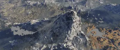
Community Shaders feature which enables rough terrain shadows with infinite distance, in game and on world maps. Supports SE, AE, and VR.


Image credit: KRZ
Community Shaders feature which enables rough terrain shadows with infinite distance, in game and on world maps. Supports SE, AE, and VR.
Image credit: KRZ
HEIGHT MAPS
This feature will only take effect if the corresponding height map of a worldspace is found. Vanilla height maps, including Skyrim itself, Solstheim and Forgotten Vale are provided as optional file. Simply download them, install as usual, and profit.
For other worldspaces, you need to create height maps by yourself, and place them in
(Game Folder)/data/textures/HeightMaps/
[worldspace editorID].HeightMap.[West cell].[South cell].[East cell].[North cell].[z black].[z white].[z min].[z max].dds
A more detailed instruction is located at
(Game Folder)/data/textures/HeightMaps/readme.txt.
Copy the height map texture to the directory above.RemoveTerrain.in the file name.Add.-32768.32768before the last two numbers in the file name. 32768 is the default [z black] and [z white] numbers used by xLODGen.
Update Community Shaders 1.1.4:
Terrain Shadows now will directly use any height map found in xLODGen outputs, which means you can simply generate height maps in xLODGen and it will work without any additional work. However, height maps in data/textures/HeightMaps/ will override xLODGen ones.
You don't need to generate height maps every time you update your LODs. Height data usually remain unchanged except for worldspace mods, which means a) the vanilla files can be used directly with most modlist and b) if you need to generate, you can do it once and use the texture basically forever.
FAQ
How do I know if a height map is found for the worldspace I am in?
- Look for the debug menu in the CS config GUI, under Terrain Shadows.
- High mountains at dawn/dusk, on world map or at a distance (shadows around the camera are covered by vanilla shadow maps).
- Note that vanilla sun angles are quite high even at daybreak. You can optionally pair the feature with EVLaS or weather mods like NAT3 that dramatically lowers the sun angle at sunrise/sunset.
- Yes.
- Not necessary for the mod to work.
- Because I want it to be independent from xLODGen. The maps are for different purposes and should be treated as such. People might want to use a higher precision map than what xLODGen can offer, or use a cropped version for better performance.
REQUIREMENTS
Community Shaders
BUGS
Report bugs on GitHub.
CREDITS
ProfJack: Coding.
doodlez, alandtse, Flayan: Community Shader framework and refactors.
sheson: xLODGen.